


Gara it

raygautier
User
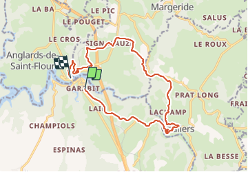

Length
16.7 km

Max alt
883 m

Uphill gradient
351 m
Km-Effort
22 km

Min alt
736 m

Downhill gradient
442 m
Boucle
No
Creation date :
2023-06-13 08:17:41.0
Updated on :
2023-06-13 13:16:10.246
4h57
Difficulty : Very difficult

FREE GPS app for hiking
 SityTrail
IGN / Geographical institutes
SityTrail Plus
The world is yours!
About
Trail Walking of 16.7 km to be discovered at Auvergne-Rhône-Alpes, Cantal, Val d'Arcomie. This trail is proposed by raygautier.
Photos

Positioning
Country:
France
Region :
Auvergne-Rhône-Alpes
Department/Province :
Cantal
Municipality :
Val d'Arcomie
Location:
Loubaresse
Start:(Dec)
Start:(UTM)
514169 ; 4979701 (31T) N.
Comments