


Albine

cedric.fargues
User
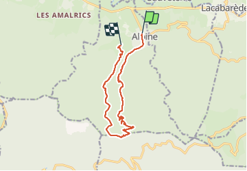

Length
13.2 km

Max alt
995 m

Uphill gradient
678 m
Km-Effort
22 km

Min alt
325 m

Downhill gradient
638 m
Boucle
No
Creation date :
2023-06-14 07:31:46.0
Updated on :
2023-06-14 13:09:28.467
5h36
Difficulty : Very difficult

FREE GPS app for hiking
 SityTrail
IGN / Geographical institutes
SityTrail Plus
The world is yours!
About
Trail Walking of 13.2 km to be discovered at Occitania, Tarn, Albine. This trail is proposed by cedric.fargues.
Positioning
Country:
France
Region :
Occitania
Department/Province :
Tarn
Municipality :
Albine
Location:
Unknown
Start:(Dec)
Start:(UTM)
462757 ; 4812090 (31T) N.
Comments