


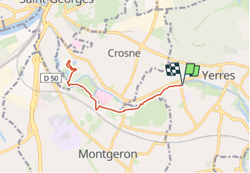
Bord de l'Yerres - Parc Pampelune Crosne 6,7 km

jeanmarcMasson
User GUIDE

Length
6.7 km

Max alt
39 m

Uphill gradient
31 m
Km-Effort
7.1 km

Min alt
31 m

Downhill gradient
31 m
Boucle
Yes
Creation date :
2023-06-14 20:45:38.316
Updated on :
2023-06-14 20:47:04.883
1h37
Difficulty : Medium

FREE GPS app for hiking
 SityTrail
IGN / Geographical institutes
SityTrail Plus
The world is yours!
About
Trail Walking of 6.7 km to be discovered at Ile-de-France, Essonne, Yerres. This trail is proposed by jeanmarcMasson.
Positioning
Country:
France
Region :
Ile-de-France
Department/Province :
Essonne
Municipality :
Yerres
Location:
Unknown
Start:(Dec)
Start:(UTM)
461675 ; 5395912 (31U) N.
Comments