


fort de fermont

luckyy
User
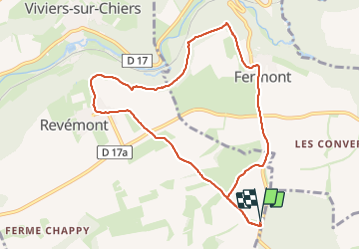

Length
8.9 km

Max alt
340 m

Uphill gradient
139 m
Km-Effort
10.8 km

Min alt
286 m

Downhill gradient
139 m
Boucle
Yes
Creation date :
2023-06-15 07:32:15.636
Updated on :
2023-06-15 10:09:00.344
2h36
Difficulty : Medium

FREE GPS app for hiking
 SityTrail
IGN / Geographical institutes
SityTrail Plus
The world is yours!
About
Trail Walking of 8.9 km to be discovered at Grand Est, Meurthe-et-Moselle, Viviers-sur-Chiers. This trail is proposed by luckyy.
Positioning
Country:
France
Region :
Grand Est
Department/Province :
Meurthe-et-Moselle
Municipality :
Viviers-sur-Chiers
Location:
Unknown
Start:(Dec)
Start:(UTM)
693132 ; 5480894 (31U) N.
Comments