


Lioran

raygautier
User
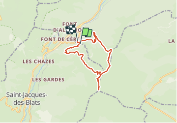

Length
12.9 km

Max alt
1839 m

Uphill gradient
722 m
Km-Effort
22 km

Min alt
1232 m

Downhill gradient
712 m
Boucle
Yes
Creation date :
2023-06-15 07:05:48.0
Updated on :
2023-06-15 14:21:22.942
7h14
Difficulty : Very difficult

FREE GPS app for hiking
 SityTrail
IGN / Geographical institutes
SityTrail Plus
The world is yours!
About
Trail Walking of 12.9 km to be discovered at Auvergne-Rhône-Alpes, Cantal, Laveissière. This trail is proposed by raygautier.
Positioning
Country:
France
Region :
Auvergne-Rhône-Alpes
Department/Province :
Cantal
Municipality :
Laveissière
Location:
Unknown
Start:(Dec)
Start:(UTM)
480214 ; 4991944 (31T) N.
Comments