


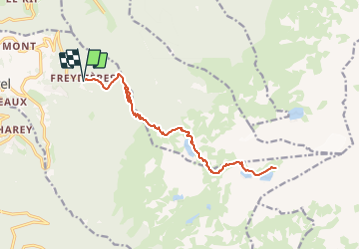
Belledonne - Lac Crozet + Lacs du Domènon

gregou74
User

Length
18.7 km

Max alt
2412 m

Uphill gradient
1286 m
Km-Effort
36 km

Min alt
1151 m

Downhill gradient
1286 m
Boucle
Yes
Creation date :
2023-06-16 09:49:16.359
Updated on :
2023-06-16 09:50:44.408
8h09
Difficulty : Very difficult

FREE GPS app for hiking
 SityTrail
IGN / Geographical institutes
SityTrail Plus
The world is yours!
About
Trail Walking of 18.7 km to be discovered at Auvergne-Rhône-Alpes, Isère, Revel. This trail is proposed by gregou74.
Description
Départ : Les Freydières
Positioning
Country:
France
Region :
Auvergne-Rhône-Alpes
Department/Province :
Isère
Municipality :
Revel
Location:
Unknown
Start:(Dec)
Start:(UTM)
727769 ; 5007710 (31T) N.
Comments