


Gtiou

raygautier
User
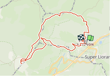

Length
12 km

Max alt
1685 m

Uphill gradient
720 m
Km-Effort
22 km

Min alt
1195 m

Downhill gradient
717 m
Boucle
Yes
Creation date :
2023-06-16 07:06:37.0
Updated on :
2023-06-16 13:10:44.494
6h02
Difficulty : Very difficult

FREE GPS app for hiking
 SityTrail
IGN / Geographical institutes
SityTrail Plus
The world is yours!
About
Trail Walking of 12 km to be discovered at Auvergne-Rhône-Alpes, Cantal, Laveissière. This trail is proposed by raygautier.
Positioning
Country:
France
Region :
Auvergne-Rhône-Alpes
Department/Province :
Cantal
Municipality :
Laveissière
Location:
Unknown
Start:(Dec)
Start:(UTM)
479757 ; 4992748 (31T) N.
Comments