


La voûte Chirac

raygautier
User
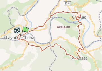

Length
12 km

Max alt
579 m

Uphill gradient
316 m
Km-Effort
16.2 km

Min alt
459 m

Downhill gradient
314 m
Boucle
Yes
Creation date :
2023-06-17 08:00:51.0
Updated on :
2023-06-17 13:34:15.929
4h11
Difficulty : Difficult

FREE GPS app for hiking
 SityTrail
IGN / Geographical institutes
SityTrail Plus
The world is yours!
About
Trail Walking of 12 km to be discovered at Auvergne-Rhône-Alpes, Haute-Loire, Lavoûte-Chilhac. This trail is proposed by raygautier.
Positioning
Country:
France
Region :
Auvergne-Rhône-Alpes
Department/Province :
Haute-Loire
Municipality :
Lavoûte-Chilhac
Location:
Unknown
Start:(Dec)
Start:(UTM)
531666 ; 4999506 (31T) N.
Comments