


Là gervanne

raygautier
User

Length
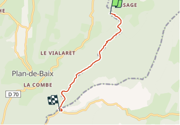
4.3 km

Max alt
514 m

Uphill gradient
33 m
Km-Effort
5.1 km

Min alt
394 m

Downhill gradient
131 m
Boucle
No
Creation date :
2023-06-18 13:14:14.0
Updated on :
2023-06-18 18:21:12.351
1h24
Difficulty : Easy

FREE GPS app for hiking
 SityTrail
IGN / Geographical institutes
SityTrail Plus
The world is yours!
About
Trail Walking of 4.3 km to be discovered at Auvergne-Rhône-Alpes, Drôme, Plan-de-Baix. This trail is proposed by raygautier.
Positioning
Country:
France
Region :
Auvergne-Rhône-Alpes
Department/Province :
Drôme
Municipality :
Plan-de-Baix
Location:
Unknown
Start:(Dec)
Start:(UTM)
673317 ; 4966081 (31T) N.
Comments