


Léry forêt et Eure

dedejojo
User
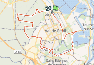

Length
23 km

Max alt
135 m

Uphill gradient
264 m
Km-Effort
26 km

Min alt
6 m

Downhill gradient
264 m
Boucle
Yes
Creation date :
2023-06-21 17:07:57.637
Updated on :
2023-06-21 17:08:52.751
5h58
Difficulty : Very difficult

FREE GPS app for hiking
 SityTrail
IGN / Geographical institutes
SityTrail Plus
The world is yours!
About
Trail Walking of 23 km to be discovered at Normandy, Eure, Léry. This trail is proposed by dedejojo.
Positioning
Country:
France
Region :
Normandy
Department/Province :
Eure
Municipality :
Léry
Location:
Unknown
Start:(Dec)
Start:(UTM)
369720 ; 5460814 (31U) N.
Comments