


maye s orne-02

gr1346
User
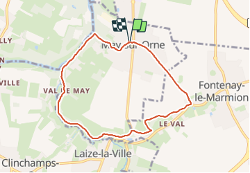

Length
7.5 km

Max alt
70 m

Uphill gradient
91 m
Km-Effort
8.7 km

Min alt
11 m

Downhill gradient
92 m
Boucle
Yes
Creation date :
2023-06-23 11:52:02.328
Updated on :
2023-06-23 14:13:37.678
1h54
Difficulty : Medium

FREE GPS app for hiking
 SityTrail
IGN / Geographical institutes
SityTrail Plus
The world is yours!
About
Trail Walking of 7.5 km to be discovered at Normandy, Calvados, May-sur-Orne. This trail is proposed by gr1346.
Positioning
Country:
France
Region :
Normandy
Department/Province :
Calvados
Municipality :
May-sur-Orne
Location:
Unknown
Start:(Dec)
Start:(UTM)
691605 ; 5442075 (30U) N.
Comments