


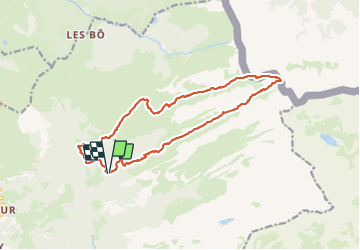
Tête De Bostan

sandra_leb
User

Length
15.9 km

Max alt
2378 m

Uphill gradient
1287 m
Km-Effort
33 km

Min alt
1110 m

Downhill gradient
1292 m
Boucle
Yes
Creation date :
2023-06-23 18:13:41.807
Updated on :
2023-06-23 18:21:19.805
7h30
Difficulty : Very difficult

FREE GPS app for hiking
 SityTrail
IGN / Geographical institutes
SityTrail Plus
The world is yours!
About
Trail Walking of 15.9 km to be discovered at Auvergne-Rhône-Alpes, Upper Savoy, Samoëns. This trail is proposed by sandra_leb.
Photos

Points of interest


Positioning
Country:
France
Region :
Auvergne-Rhône-Alpes
Department/Province :
Upper Savoy
Municipality :
Samoëns
Location:
Unknown
Start:(Dec)
Start:(UTM)
326190 ; 5109021 (32T) N.
Comments