


Charmette > Charmant Som

jean52
User
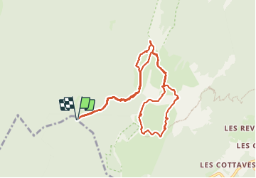

Length
11 km

Max alt
1857 m

Uphill gradient
751 m
Km-Effort
21 km

Min alt
1277 m

Downhill gradient
751 m
Boucle
Yes
Creation date :
2023-06-24 06:51:55.0
Updated on :
2023-08-16 13:29:02.509
4h08
Difficulty : Very difficult

FREE GPS app for hiking
 SityTrail
IGN / Geographical institutes
SityTrail Plus
The world is yours!
About
Trail Walking of 11 km to be discovered at Auvergne-Rhône-Alpes, Isère, Proveysieux. This trail is proposed by jean52.
Positioning
Country:
France
Region :
Auvergne-Rhône-Alpes
Department/Province :
Isère
Municipality :
Proveysieux
Location:
Unknown
Start:(Dec)
Start:(UTM)
714762 ; 5022343 (31T) N.
Comments