


olan

m@nu
User
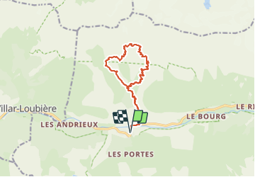

Length
15.6 km

Max alt
2742 m

Uphill gradient
1633 m
Km-Effort
37 km

Min alt
1091 m

Downhill gradient
1632 m
Boucle
Yes
Creation date :
2023-06-24 09:03:11.92
Updated on :
2023-06-24 15:41:06.885
6h36
Difficulty : Very easy

FREE GPS app for hiking
 SityTrail
IGN / Geographical institutes
SityTrail Plus
The world is yours!
About
Trail Walking of 15.6 km to be discovered at Provence-Alpes-Côte d'Azur, Hautes-Alpes, La Chapelle-en-Valgaudémar. This trail is proposed by m@nu.
Positioning
Country:
France
Region :
Provence-Alpes-Côte d'Azur
Department/Province :
Hautes-Alpes
Municipality :
La Chapelle-en-Valgaudémar
Location:
Unknown
Start:(Dec)
Start:(UTM)
278301 ; 4966535 (32T) N.
Comments