


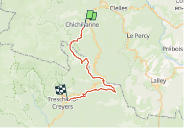
Chichilianne pas de l'Essaure Col de Menée Les Nonnieres

planets
User

Length
21 km

Max alt
1672 m

Uphill gradient
1091 m
Km-Effort
36 km

Min alt
869 m

Downhill gradient
1236 m
Boucle
No
Creation date :
2023-06-24 06:47:28.497
Updated on :
2023-06-24 16:37:55.847
5h58
Difficulty : Medium

FREE GPS app for hiking
 SityTrail
IGN / Geographical institutes
SityTrail Plus
The world is yours!
About
Trail Walking of 21 km to be discovered at Auvergne-Rhône-Alpes, Isère, Chichilianne. This trail is proposed by planets.
Positioning
Country:
France
Region :
Auvergne-Rhône-Alpes
Department/Province :
Isère
Municipality :
Chichilianne
Location:
Unknown
Start:(Dec)
Start:(UTM)
703779 ; 4964996 (31T) N.
Comments