


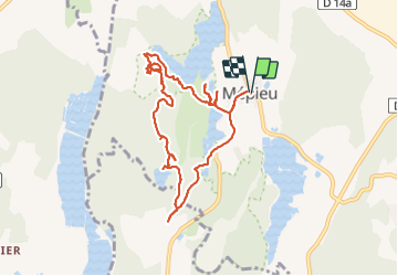
Boucle autour de Meypieu - 25 juin 2023

morganee
User

Length
9.7 km

Max alt
281 m

Uphill gradient
93 m
Km-Effort
10.9 km

Min alt
246 m

Downhill gradient
92 m
Boucle
Yes
Creation date :
2023-06-25 12:42:46.744
Updated on :
2023-06-25 15:47:26.986
3h04
Difficulty : Easy

FREE GPS app for hiking
 SityTrail
IGN / Geographical institutes
SityTrail Plus
The world is yours!
About
Trail Walking of 9.7 km to be discovered at Auvergne-Rhône-Alpes, Isère, Creys-Mépieu. This trail is proposed by morganee.
Positioning
Country:
France
Region :
Auvergne-Rhône-Alpes
Department/Province :
Isère
Municipality :
Creys-Mépieu
Location:
Unknown
Start:(Dec)
Start:(UTM)
690376 ; 5068925 (31T) N.
Comments