


230626 Eygurande Tour lac

randodan
User
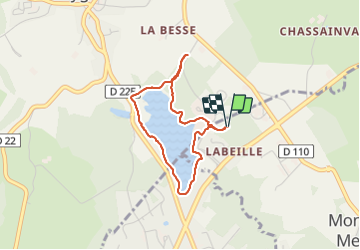

Length
3.1 km

Max alt
726 m

Uphill gradient
44 m
Km-Effort
3.7 km

Min alt
704 m

Downhill gradient
44 m
Boucle
Yes
Creation date :
2023-06-26 07:19:59.858
Updated on :
2023-06-26 08:39:19.28
1h18
Difficulty : Easy

FREE GPS app for hiking
 SityTrail
IGN / Geographical institutes
SityTrail Plus
The world is yours!
About
Trail Walking of 3.1 km to be discovered at New Aquitaine, Corrèze, Monestier-Merlines. This trail is proposed by randodan.
Description
Tour de l'étang de l'Abeille
diverticule
Positioning
Country:
France
Region :
New Aquitaine
Department/Province :
Corrèze
Municipality :
Monestier-Merlines
Location:
Unknown
Start:(Dec)
Start:(UTM)
458152 ; 5055790 (31T) N.
Comments