


26 juin 23 Ermitage Ucel

Linerou
User
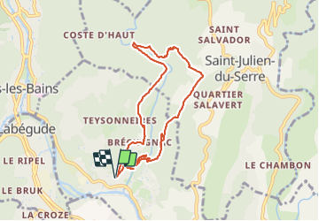

Length
8.4 km

Max alt
415 m

Uphill gradient
250 m
Km-Effort
11.7 km

Min alt
232 m

Downhill gradient
249 m
Boucle
Yes
Creation date :
2023-06-26 07:04:07.674
Updated on :
2023-06-26 10:01:52.538
2h57
Difficulty : Medium

FREE GPS app for hiking
 SityTrail
IGN / Geographical institutes
SityTrail Plus
The world is yours!
About
Trail Walking of 8.4 km to be discovered at Auvergne-Rhône-Alpes, Ardèche, Ucel. This trail is proposed by Linerou.
Positioning
Country:
France
Region :
Auvergne-Rhône-Alpes
Department/Province :
Ardèche
Municipality :
Ucel
Location:
Unknown
Start:(Dec)
Start:(UTM)
609823 ; 4944215 (31T) N.
Comments