


les crêtes de charvet

labarone
User
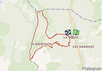

Length
12.7 km

Max alt
2388 m

Uphill gradient
1044 m
Km-Effort
27 km

Min alt
1389 m

Downhill gradient
1044 m
Boucle
Yes
Creation date :
2023-06-27 06:42:22.447
Updated on :
2023-06-27 14:26:51.51
7h37
Difficulty : Difficult

FREE GPS app for hiking
 SityTrail
IGN / Geographical institutes
SityTrail Plus
The world is yours!
About
Trail Walking of 12.7 km to be discovered at Auvergne-Rhône-Alpes, Savoy, Pralognan-la-Vanoise. This trail is proposed by labarone.
Description
ré difficile Attention au passage névés. Prevoir par prudence crampons neige
les crêtes supersuper spendide mais a eviter si vertige
Positioning
Country:
France
Region :
Auvergne-Rhône-Alpes
Department/Province :
Savoy
Municipality :
Pralognan-la-Vanoise
Location:
Unknown
Start:(Dec)
Start:(UTM)
320684 ; 5029454 (32T) N.
Comments