


2023-06-27_20h37m56_Mullerthal_E1

Laurence Lallemand
User
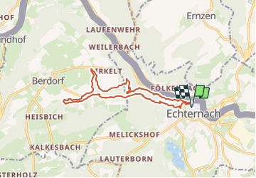

Length
13.4 km

Max alt
341 m

Uphill gradient
330 m
Km-Effort
17.8 km

Min alt
161 m

Downhill gradient
330 m
Boucle
Yes
Creation date :
2023-06-27 18:37:56.534
Updated on :
2023-07-12 19:27:59.993
4h02
Difficulty : Difficult

FREE GPS app for hiking
 SityTrail
IGN / Geographical institutes
SityTrail Plus
The world is yours!
About
Trail Walking of 13.4 km to be discovered at Unknown, Canton Echternach, Echternach. This trail is proposed by Laurence Lallemand.
Positioning
Country:
Luxembourg
Region :
Unknown
Department/Province :
Canton Echternach
Municipality :
Echternach
Location:
Unknown
Start:(Dec)
Start:(UTM)
314439 ; 5521121 (32U) N.
Comments