


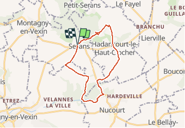
Serans - Hadancourt-Nucourt

marcel.F
User

Length
11.7 km

Max alt
192 m

Uphill gradient
172 m
Km-Effort
14 km

Min alt
85 m

Downhill gradient
177 m
Boucle
Yes
Creation date :
2019-04-01 20:24:58.105
Updated on :
2019-04-19 16:55:24.621
3h04
Difficulty : Easy

FREE GPS app for hiking
 SityTrail
IGN / Geographical institutes
SityTrail Plus
The world is yours!
About
Trail Walking of 11.7 km to be discovered at Hauts-de-France, Oise, Serans. This trail is proposed by marcel.F.
Description
Boucle au départ rue de la mairie à Serans
Positioning
Country:
France
Region :
Hauts-de-France
Department/Province :
Oise
Municipality :
Serans
Location:
Unknown
Start:(Dec)
Start:(UTM)
414781 ; 5448904 (31U) N.
Comments
