


Les 3 becs

raygautier
User

Length
15.8 km

Max alt
1565 m

Uphill gradient
1180 m
Km-Effort
32 km

Min alt
623 m

Downhill gradient
1180 m
Boucle
Yes
Creation date :
2023-06-29 06:30:31.0
Updated on :
2023-06-29 14:22:14.914
7h50
Difficulty : Very difficult

FREE GPS app for hiking
 SityTrail
IGN / Geographical institutes
SityTrail Plus
The world is yours!
About
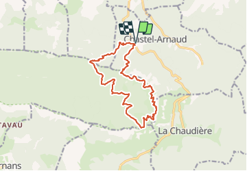
Trail Walking of 15.8 km to be discovered at Auvergne-Rhône-Alpes, Drôme, Chastel-Arnaud. This trail is proposed by raygautier.
Positioning
Country:
France
Region :
Auvergne-Rhône-Alpes
Department/Province :
Drôme
Municipality :
Chastel-Arnaud
Location:
Unknown
Start:(Dec)
Start:(UTM)
673730 ; 4947901 (31T) N.
Comments