


TET Ouest V2

DaVinci
User
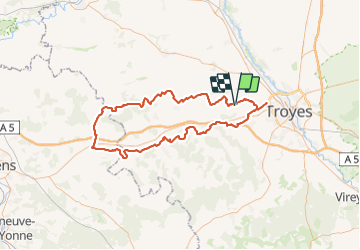

Length
112 km

Max alt
264 m

Uphill gradient
1421 m
Km-Effort
131 km

Min alt
99 m

Downhill gradient
1420 m
Boucle
Yes
Creation date :
2023-07-02 08:03:30.987
Updated on :
2023-08-26 12:53:49.986
1h21
Difficulty : Medium

FREE GPS app for hiking
 SityTrail
IGN / Geographical institutes
SityTrail Plus
The world is yours!
About
Trail Moto cross of 112 km to be discovered at Grand Est, Aube, Macey. This trail is proposed by DaVinci.
Positioning
Country:
France
Region :
Grand Est
Department/Province :
Aube
Municipality :
Macey
Location:
Unknown
Start:(Dec)
Start:(UTM)
568658 ; 5350748 (31U) N.
Comments