


Argentons-sur-Creuse

gdela
User
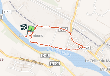

Length
1.8 km

Max alt
106 m

Uphill gradient
9 m
Km-Effort
2 km

Min alt
99 m

Downhill gradient
9 m
Boucle
Yes
Creation date :
2023-07-02 14:34:46.18
Updated on :
2023-07-02 15:12:25.377
29m
Difficulty : Easy

FREE GPS app for hiking
 SityTrail
IGN / Geographical institutes
SityTrail Plus
The world is yours!
About
Trail Walking of 1.8 km to be discovered at Centre-Loire Valley, Indre, Argenton-sur-Creuse. This trail is proposed by gdela.
Positioning
Country:
France
Region :
Centre-Loire Valley
Department/Province :
Indre
Municipality :
Argenton-sur-Creuse
Location:
Unknown
Start:(Dec)
Start:(UTM)
385481 ; 5161310 (31T) N.
Comments