


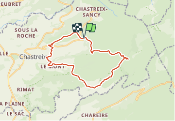
la.fontaine salée puis la vessaire

jeanic63
User

Length
14.9 km

Max alt
1387 m

Uphill gradient
480 m
Km-Effort
21 km

Min alt
1048 m

Downhill gradient
480 m
Boucle
Yes
Creation date :
2023-07-03 05:43:35.208
Updated on :
2023-07-03 12:10:31.897
5h33
Difficulty : Very difficult

FREE GPS app for hiking
 SityTrail
IGN / Geographical institutes
SityTrail Plus
The world is yours!
About
Trail Walking of 14.9 km to be discovered at Auvergne-Rhône-Alpes, Puy-de-Dôme, Chastreix. This trail is proposed by jeanic63.
Description
départ parking 3 km après village de Baffaud
Positioning
Country:
France
Region :
Auvergne-Rhône-Alpes
Department/Province :
Puy-de-Dôme
Municipality :
Chastreix
Location:
Unknown
Start:(Dec)
Start:(UTM)
482094 ; 5040880 (31T) N.
Comments