


Les Chemins d'Isabelle P3

CDSM 55
User

Length
54 km

Max alt
436 m

Uphill gradient
988 m
Km-Effort
67 km

Min alt
263 m

Downhill gradient
987 m
Boucle
Yes
Creation date :
2023-07-03 17:18:33.848
Updated on :
2023-07-03 17:24:44.086
4h40
Difficulty : Very difficult

FREE GPS app for hiking
 SityTrail
IGN / Geographical institutes
SityTrail Plus
The world is yours!
About
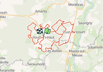
Trail Mountain bike of 54 km to be discovered at Grand Est, Meuse, Vouthon-Haut. This trail is proposed by CDSM 55.
Description
Pas pour tous !!!
mais une très belle balade s on prend son temps
Photos


Positioning
Country:
France
Region :
Grand Est
Department/Province :
Meuse
Municipality :
Vouthon-Haut
Location:
Unknown
Start:(Dec)
Start:(UTM)
693473 ; 5372512 (31U) N.
Comments