


les sources

noelphil
User
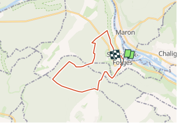

Length
12.6 km

Max alt
355 m

Uphill gradient
261 m
Km-Effort
16.1 km

Min alt
222 m

Downhill gradient
262 m
Boucle
Yes
Creation date :
2023-07-03 17:56:29.858
Updated on :
2023-07-03 17:57:33.753
3h38
Difficulty : Difficult

FREE GPS app for hiking
 SityTrail
IGN / Geographical institutes
SityTrail Plus
The world is yours!
About
Trail Walking of 12.6 km to be discovered at Grand Est, Meurthe-et-Moselle, Sexey-aux-Forges. This trail is proposed by noelphil.
Positioning
Country:
France
Region :
Grand Est
Department/Province :
Meurthe-et-Moselle
Municipality :
Sexey-aux-Forges
Location:
Unknown
Start:(Dec)
Start:(UTM)
282326 ; 5389440 (32U) N.
Comments