


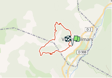
La+Croix+du+Puy

jmdelva
User

Length
6 km

Max alt
1688 m

Uphill gradient
386 m
Km-Effort
11.1 km

Min alt
1295 m

Downhill gradient
386 m
Boucle
Yes
Creation date :
2023-07-04 08:38:47.847
Updated on :
2023-07-04 08:44:53.383
2h32
Difficulty : Medium

FREE GPS app for hiking
 SityTrail
IGN / Geographical institutes
SityTrail Plus
The world is yours!
About
Trail Walking of 6 km to be discovered at Provence-Alpes-Côte d'Azur, Alpes-de-Haute-Provence, Villars-Colmars. This trail is proposed by jmdelva.
Positioning
Country:
France
Region :
Provence-Alpes-Côte d'Azur
Department/Province :
Alpes-de-Haute-Provence
Municipality :
Villars-Colmars
Location:
Unknown
Start:(Dec)
Start:(UTM)
308183 ; 4892819 (32T) N.
Comments