


Florent

Divio
User

Length
12.2 km

Max alt
256 m

Uphill gradient
191 m
Km-Effort
14.8 km

Min alt
151 m

Downhill gradient
192 m
Boucle
Yes
Creation date :
2023-07-04 06:29:18.224
Updated on :
2023-07-04 09:02:51.368
2h33
Difficulty : Very easy

FREE GPS app for hiking
 SityTrail
IGN / Geographical institutes
SityTrail Plus
The world is yours!
About
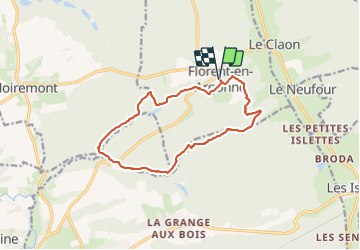
Trail Nordic walking of 12.2 km to be discovered at Grand Est, Marne, Florent-en-Argonne. This trail is proposed by Divio.
Positioning
Country:
France
Region :
Grand Est
Department/Province :
Marne
Municipality :
Florent-en-Argonne
Location:
Unknown
Start:(Dec)
Start:(UTM)
642557 ; 5444258 (31U) N.
Comments