


Jujurieu

Dupuybadonniere
User
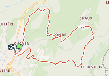

Length
7.4 km

Max alt
488 m

Uphill gradient
259 m
Km-Effort
10.8 km

Min alt
301 m

Downhill gradient
263 m
Boucle
Yes
Creation date :
2023-07-04 07:52:05.297
Updated on :
2023-07-04 11:39:41.712
3h47
Difficulty : Medium

FREE GPS app for hiking
 SityTrail
IGN / Geographical institutes
SityTrail Plus
The world is yours!
About
Trail Walking of 7.4 km to be discovered at Auvergne-Rhône-Alpes, Ain, Jujurieux. This trail is proposed by Dupuybadonniere.
Positioning
Country:
France
Region :
Auvergne-Rhône-Alpes
Department/Province :
Ain
Municipality :
Jujurieux
Location:
Unknown
Start:(Dec)
Start:(UTM)
686513 ; 5101585 (31T) N.
Comments