


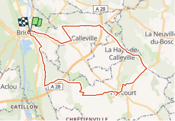
Brionne-Harcourt

werth
User

Length
21 km

Max alt
145 m

Uphill gradient
232 m
Km-Effort
24 km

Min alt
54 m

Downhill gradient
231 m
Boucle
Yes
Creation date :
2023-07-04 07:09:00.659
Updated on :
2023-07-04 13:51:27.917
5h36
Difficulty : Medium

FREE GPS app for hiking
 SityTrail
IGN / Geographical institutes
SityTrail Plus
The world is yours!
About
Trail Walking of 21 km to be discovered at Normandy, Eure, Brionne. This trail is proposed by werth.
Photos


Positioning
Country:
France
Region :
Normandy
Department/Province :
Eure
Municipality :
Brionne
Location:
Unknown
Start:(Dec)
Start:(UTM)
333908 ; 5451605 (31U) N.
Comments