


Nantua

Dupuybadonniere
User

Length
10.2 km

Max alt
425 m

Uphill gradient
151 m
Km-Effort
12.2 km

Min alt
380 m

Downhill gradient
151 m
Boucle
Yes
Creation date :
2023-07-06 08:03:50.485
Updated on :
2023-07-06 12:54:42.08
2h54
Difficulty : Difficult

FREE GPS app for hiking
 SityTrail
IGN / Geographical institutes
SityTrail Plus
The world is yours!
About
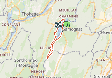
Trail Walking of 10.2 km to be discovered at Auvergne-Rhône-Alpes, Ain, Samognat. This trail is proposed by Dupuybadonniere.
Photos


Positioning
Country:
France
Region :
Auvergne-Rhône-Alpes
Department/Province :
Ain
Municipality :
Samognat
Location:
Unknown
Start:(Dec)
Start:(UTM)
697696 ; 5125749 (31T) N.
Comments