


maro n

noelphil
User
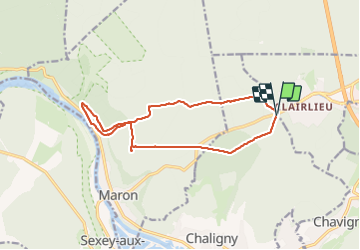

Length
13.3 km

Max alt
413 m

Uphill gradient
232 m
Km-Effort
16.4 km

Min alt
229 m

Downhill gradient
230 m
Boucle
Yes
Creation date :
2023-06-06 11:57:37.704
Updated on :
2023-07-06 14:03:09.334
3h34
Difficulty : Difficult

FREE GPS app for hiking
 SityTrail
IGN / Geographical institutes
SityTrail Plus
The world is yours!
About
Trail Walking of 13.3 km to be discovered at Grand Est, Meurthe-et-Moselle, Chaligny. This trail is proposed by noelphil.
Positioning
Country:
France
Region :
Grand Est
Department/Province :
Meurthe-et-Moselle
Municipality :
Chaligny
Location:
Unknown
Start:(Dec)
Start:(UTM)
286668 ; 5393013 (32U) N.
Comments