


risoul

c54vest
User

Length
39 km

Max alt
1880 m

Uphill gradient
1166 m
Km-Effort
53 km

Min alt
886 m

Downhill gradient
673 m
Boucle
No
Creation date :
2023-07-07 11:40:06.906
Updated on :
2023-07-07 11:40:08.844
3h13
Difficulty : Very difficult

FREE GPS app for hiking
 SityTrail
IGN / Geographical institutes
SityTrail Plus
The world is yours!
About
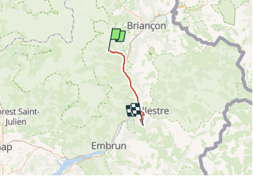
Trail Road bike of 39 km to be discovered at Provence-Alpes-Côte d'Azur, Hautes-Alpes, Puy-Saint-Vincent. This trail is proposed by c54vest.
Positioning
Country:
France
Region :
Provence-Alpes-Côte d'Azur
Department/Province :
Hautes-Alpes
Municipality :
Puy-Saint-Vincent
Location:
Unknown
Start:(Dec)
Start:(UTM)
301998 ; 4966850 (32T) N.
Comments