


les échelles

panetJeanLuc
User

Length
3.2 km

Max alt
600 m

Uphill gradient
211 m
Km-Effort
6 km

Min alt
431 m

Downhill gradient
209 m
Boucle
No
Creation date :
2023-06-29 07:04:06.493
Updated on :
2023-07-08 11:59:10.313
16m
Difficulty : Medium

FREE GPS app for hiking
 SityTrail
IGN / Geographical institutes
SityTrail Plus
The world is yours!
About
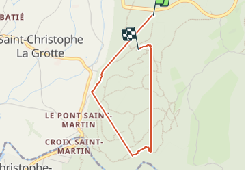
Trail Walking of 3.2 km to be discovered at Auvergne-Rhône-Alpes, Savoy, Saint-Christophe. This trail is proposed by panetJeanLuc.
Positioning
Country:
France
Region :
Auvergne-Rhône-Alpes
Department/Province :
Savoy
Municipality :
Saint-Christophe
Location:
Unknown
Start:(Dec)
Start:(UTM)
718290 ; 5037078 (31T) N.
Comments