


Brugg - Rohr (SO)

bffcuc
User
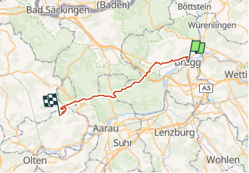

Length
30 km

Max alt
962 m

Uphill gradient
1105 m
Km-Effort
44 km

Min alt
340 m

Downhill gradient
881 m
Boucle
No
Creation date :
2014-12-10 00:00:00.0
Updated on :
2014-12-10 00:00:00.0
8h30
Difficulty : Unknown

FREE GPS app for hiking
 SityTrail
IGN / Geographical institutes
SityTrail Plus
The world is yours!
About
Trail Other activity of 30 km to be discovered at Aargau, Bezirk Brugg, Brugg. This trail is proposed by bffcuc.
Positioning
Country:
Switzerland
Region :
Aargau
Department/Province :
Bezirk Brugg
Municipality :
Brugg
Location:
Unknown
Start:(Dec)
Start:(UTM)
440401 ; 5258939 (32T) N.
Comments