


rando digestive Multipattes

okfred26
User
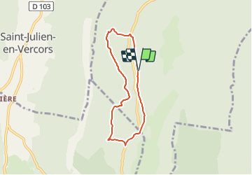

Length
5.9 km

Max alt
1441 m

Uphill gradient
191 m
Km-Effort
8.4 km

Min alt
1317 m

Downhill gradient
191 m
Boucle
Yes
Creation date :
2023-07-08 14:30:39.137
Updated on :
2023-07-08 14:31:13.676
1h54
Difficulty : Easy

FREE GPS app for hiking
 SityTrail
IGN / Geographical institutes
SityTrail Plus
The world is yours!
About
Trail On foot of 5.9 km to be discovered at Auvergne-Rhône-Alpes, Isère, Villard-de-Lans. This trail is proposed by okfred26.
Positioning
Country:
France
Region :
Auvergne-Rhône-Alpes
Department/Province :
Isère
Municipality :
Villard-de-Lans
Location:
Unknown
Start:(Dec)
Start:(UTM)
695050 ; 4990963 (31T) N.
Comments