


jg517

Jack-94
User
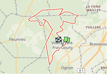

Length
20 km

Max alt
239 m

Uphill gradient
352 m
Km-Effort
25 km

Min alt
92 m

Downhill gradient
353 m
Boucle
Yes
Creation date :
2023-07-08 07:44:13.421
Updated on :
2023-07-09 10:28:22.699
6h43
Difficulty : Very difficult

FREE GPS app for hiking
 SityTrail
IGN / Geographical institutes
SityTrail Plus
The world is yours!
About
Trail Walking of 20 km to be discovered at Hauts-de-France, Oise, Villers-Saint-Frambourg-Ognon. This trail is proposed by Jack-94.
Positioning
Country:
France
Region :
Hauts-de-France
Department/Province :
Oise
Municipality :
Villers-Saint-Frambourg-Ognon
Location:
Unknown
Start:(Dec)
Start:(UTM)
473755 ; 5455819 (31U) N.
Comments