


Cazals brousse 2

Glurps
User
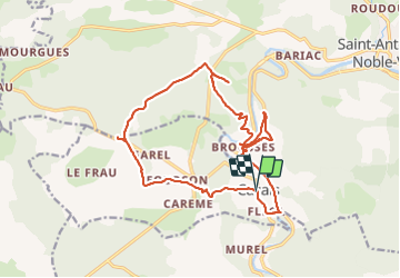

Length
19.1 km

Max alt
316 m

Uphill gradient
461 m
Km-Effort
25 km

Min alt
111 m

Downhill gradient
460 m
Boucle
Yes
Creation date :
2023-07-09 08:08:33.0
Updated on :
2023-07-09 15:32:19.784
5h33
Difficulty : Difficult

FREE GPS app for hiking
 SityTrail
IGN / Geographical institutes
SityTrail Plus
The world is yours!
About
Trail Walking of 19.1 km to be discovered at Occitania, Tarn-et-Garonne, Cazals. This trail is proposed by Glurps.
Positioning
Country:
France
Region :
Occitania
Department/Province :
Tarn-et-Garonne
Municipality :
Cazals
Location:
Unknown
Start:(Dec)
Start:(UTM)
397245 ; 4886232 (31T) N.
Comments