


Tour des grandes Rousses - 9 juillet 2023

morganee
User
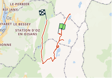

Length
16 km

Max alt
2803 m

Uphill gradient
278 m
Km-Effort
22 km

Min alt
2039 m

Downhill gradient
1031 m
Boucle
No
Creation date :
2023-07-09 07:23:52.564
Updated on :
2023-07-09 18:33:45.594
5h45
Difficulty : Medium

FREE GPS app for hiking
 SityTrail
IGN / Geographical institutes
SityTrail Plus
The world is yours!
About
Trail Walking of 16 km to be discovered at Auvergne-Rhône-Alpes, Isère, Oz. This trail is proposed by morganee.
Positioning
Country:
France
Region :
Auvergne-Rhône-Alpes
Department/Province :
Isère
Municipality :
Oz
Location:
Unknown
Start:(Dec)
Start:(UTM)
272401 ; 5001279 (32T) N.
Comments