


Olne - Bois d'Olne

Delhezpy
User
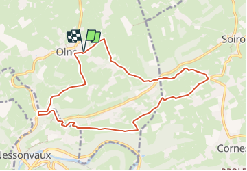

Length
8.8 km

Max alt
273 m

Uphill gradient
243 m
Km-Effort
12.1 km

Min alt
123 m

Downhill gradient
243 m
Boucle
Yes
Creation date :
2023-07-10 12:40:57.842
Updated on :
2023-07-10 12:41:53.393
2h44
Difficulty : Difficult

FREE GPS app for hiking
 SityTrail
IGN / Geographical institutes
SityTrail Plus
The world is yours!
About
Trail Walking of 8.8 km to be discovered at Wallonia, Liège, Olne. This trail is proposed by Delhezpy.
Positioning
Country:
Belgium
Region :
Wallonia
Department/Province :
Liège
Municipality :
Olne
Location:
Unknown
Start:(Dec)
Start:(UTM)
694818 ; 5607864 (31U) N.
Comments