


approche voie escalade chaud biz Ailefroide

fredtruc27
User
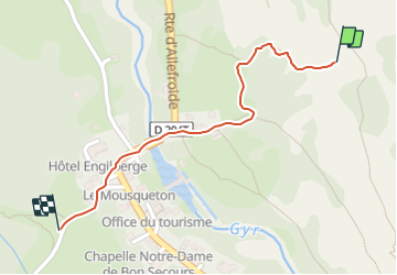

Length
668 m

Max alt
1617 m

Uphill gradient
2 m
Km-Effort
954 m

Min alt
1508 m

Downhill gradient
80 m
Boucle
No
Creation date :
2023-07-10 14:29:18.506
Updated on :
2023-07-10 14:47:33.845
15m
Difficulty : Easy

FREE GPS app for hiking
 SityTrail
IGN / Geographical institutes
SityTrail Plus
The world is yours!
About
Trail Walking of 668 m to be discovered at Provence-Alpes-Côte d'Azur, Hautes-Alpes, Vallouise-Pelvoux. This trail is proposed by fredtruc27.
Description
approche de la voie d'escalade "chaud biz"
Positioning
Country:
France
Region :
Provence-Alpes-Côte d'Azur
Department/Province :
Hautes-Alpes
Municipality :
Vallouise-Pelvoux
Location:
Pelvoux
Start:(Dec)
Start:(UTM)
298612 ; 4973878 (32T) N.
Comments