


Fontanalbe - Mont Saint Marie en boucle

aris
User
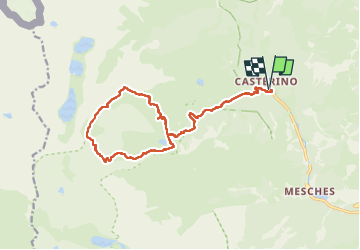

Length
18.8 km

Max alt
2717 m

Uphill gradient
1269 m
Km-Effort
36 km

Min alt
1545 m

Downhill gradient
1267 m
Boucle
Yes
Creation date :
2023-07-12 06:25:36.073
Updated on :
2025-07-02 19:15:16.904
9h16
Difficulty : Difficult

FREE GPS app for hiking
 SityTrail
IGN / Geographical institutes
SityTrail Plus
The world is yours!
About
Trail Walking of 18.8 km to be discovered at Provence-Alpes-Côte d'Azur, Maritime Alps, Tende. This trail is proposed by aris.
Positioning
Country:
France
Region :
Provence-Alpes-Côte d'Azur
Department/Province :
Maritime Alps
Municipality :
Tende
Location:
Unknown
Start:(Dec)
Start:(UTM)
380533 ; 4883680 (32T) N.
Comments