


Chemin d'Isabelle partiel

CDSM 55
User

Length
14.6 km

Max alt
436 m

Uphill gradient
213 m
Km-Effort
17.4 km

Min alt
322 m

Downhill gradient
217 m
Boucle
Yes
Creation date :
2023-07-14 08:07:18.769
Updated on :
2023-07-14 09:29:03.354
1h08
Difficulty : Easy

FREE GPS app for hiking
 SityTrail
IGN / Geographical institutes
SityTrail Plus
The world is yours!
About
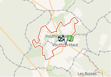
Trail Mountain bike of 14.6 km to be discovered at Grand Est, Meuse, Vouthon-Haut. This trail is proposed by CDSM 55.
Description
une partie de notre rando VTT 2023
Positioning
Country:
France
Region :
Grand Est
Department/Province :
Meuse
Municipality :
Vouthon-Haut
Location:
Unknown
Start:(Dec)
Start:(UTM)
693503 ; 5372527 (31U) N.
Comments
Facile accessible à tous, sauf montée du Saussy