


jour 3 essai

fredtruc27
User
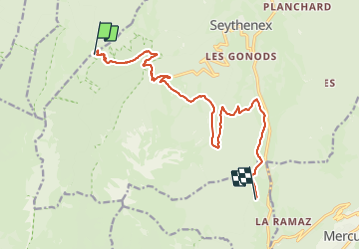

Length
13.9 km

Max alt
1427 m

Uphill gradient
704 m
Km-Effort
25 km

Min alt
764 m

Downhill gradient
1237 m
Boucle
No
Creation date :
2023-07-15 05:27:32.81
Updated on :
2023-07-15 05:27:35.6
5h41
Difficulty : Very difficult

FREE GPS app for hiking
 SityTrail
IGN / Geographical institutes
SityTrail Plus
The world is yours!
About
Trail Walking of 13.9 km to be discovered at Auvergne-Rhône-Alpes, Upper Savoy, Faverges-Seythenex. This trail is proposed by fredtruc27.
Positioning
Country:
France
Region :
Auvergne-Rhône-Alpes
Department/Province :
Upper Savoy
Municipality :
Faverges-Seythenex
Location:
Seythenex
Start:(Dec)
Start:(UTM)
285872 ; 5066498 (32T) N.
Comments