


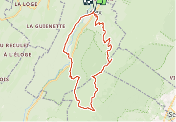
Crêt de la Neige et Reculet

loicthev
User

Length
18.7 km

Max alt
1711 m

Uphill gradient
1212 m
Km-Effort
35 km

Min alt
842 m

Downhill gradient
1212 m
Boucle
Yes
Creation date :
2023-07-15 07:35:36.484
Updated on :
2023-07-15 15:05:15.945
5h07
Difficulty : Medium

FREE GPS app for hiking
 SityTrail
IGN / Geographical institutes
SityTrail Plus
The world is yours!
About
Trail Walking of 18.7 km to be discovered at Auvergne-Rhône-Alpes, Ain, Lélex. This trail is proposed by loicthev.
Description
Crêt de la Neige et le Reculet
Lélex > Grand Crêt > Crêt de la neige > Thoiry devant > Le Reculet > Lélex
Positioning
Country:
France
Region :
Auvergne-Rhône-Alpes
Department/Province :
Ain
Municipality :
Lélex
Location:
Unknown
Start:(Dec)
Start:(UTM)
726514 ; 5131923 (31T) N.
Comments