


sur les chemins d'Isabelle partiel les Roises

CDSM 55
User
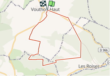

Length
8.4 km

Max alt
413 m

Uphill gradient
197 m
Km-Effort
11 km

Min alt
307 m

Downhill gradient
196 m
Boucle
Yes
Creation date :
2023-07-16 13:02:02.157
Updated on :
2023-07-16 16:47:00.13
1h08
Difficulty : Medium
1h08
Difficulty : Easy

FREE GPS app for hiking
 SityTrail
IGN / Geographical institutes
SityTrail Plus
The world is yours!
About
Trail Walking of 8.4 km to be discovered at Grand Est, Meuse, Vouthon-Haut. This trail is proposed by CDSM 55.
Description
pas tout enregistré...11 km
Photos


Positioning
Country:
France
Region :
Grand Est
Department/Province :
Meuse
Municipality :
Vouthon-Haut
Location:
Unknown
Start:(Dec)
Start:(UTM)
693504 ; 5372534 (31U) N.
Comments
sympa, mais enregistrement nul ??? Le logiciel a fait de gros raccourcis, km réel 11 !!