


Valmeinier-Découverte

nicolas54230
User
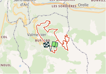

Length
18.2 km

Max alt
2575 m

Uphill gradient
1108 m
Km-Effort
33 km

Min alt
1566 m

Downhill gradient
1108 m
Boucle
Yes
Creation date :
2023-07-16 18:22:11.817
Updated on :
2023-07-16 18:23:08.675
7h29
Difficulty : Very difficult

FREE GPS app for hiking
 SityTrail
IGN / Geographical institutes
SityTrail Plus
The world is yours!
About
Trail Walking of 18.2 km to be discovered at Auvergne-Rhône-Alpes, Savoy, Valmeinier. This trail is proposed by nicolas54230.
Positioning
Country:
France
Region :
Auvergne-Rhône-Alpes
Department/Province :
Savoy
Municipality :
Valmeinier
Location:
Unknown
Start:(Dec)
Start:(UTM)
303354 ; 5005070 (32T) N.
Comments