


клаурлвее
© OpenStreetMap contributors


2h20
Difficulty : Medium


Length
8.4 km
Max alt
413 m
Uphill gradient
115 m
Km-Effort
9.9 km
Min alt
341 m
Downhill gradient
124 m
Boucle
Yes
Creation date :
2023-07-18 11:44:15.523
Updated on :
2023-07-18 14:05:25.897
2h20
Difficulty : Medium
FREE GPS app for hiking
 SityTrail
IGN / Geographical institutes
SityTrail Plus
The world is yours!
About
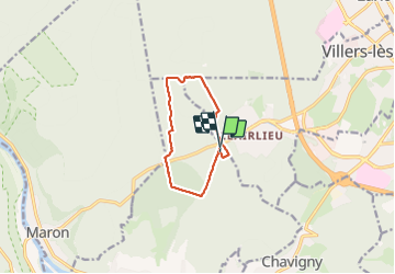
Trail Walking of 8.4 km to be discovered at Grand Est, Meurthe-et-Moselle, Chaligny. This trail is proposed by jerome-dupont@laposte.net.
Description
ипрсне
Positioning
Country:
France
Region :
Grand Est
Department/Province :
Meurthe-et-Moselle
Municipality :
Chaligny
Location:
Unknown
Start:(Dec)
Start:(UTM)
286587 ; 5392860 (32U) N.
Comments