Trail Walking Vianden - Vianden : Télésiège & Château  - Photo

Vianden : Télésiège & Château

© OpenStreetMap contributors
Length
Length
4 km
Max alt
Max alt
447 m
Uphill gradient
Uphill gradient
183 m
Km-Effort
Km-Effort  
6.5 km
Min alt
Min alt
273 m
Downhill gradient
Downhill gradient
188 m
Boucle
Boucle
Yes
Creation date :
2023-07-18 15:56:52.73
Updated on :
2025-04-10 12:14:39.203

(2 Reviews)

Walking
Walking
1h28
Difficulty : Medium

Scan this QR Code to open this trail in the SityTrail application

FREE GPS app for hiking

Logo SityTrail SityTrail

IGN / Geographical institutes

Download SityTrail from the App Store Download SityTrail from Google Play

Logo SityTrail SityTrail Plus

The world is yours!

Download SityTrail from the App Store Download SityTrail from Google Play Download SityTrail on Huawei AppGallery

About

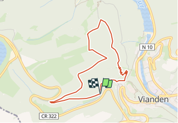
Trail Walking of 4 km to be discovered at Unknown, Canton Vianden, Vianden. This trail is proposed by Je vous emmène sur mes chemins .

Description

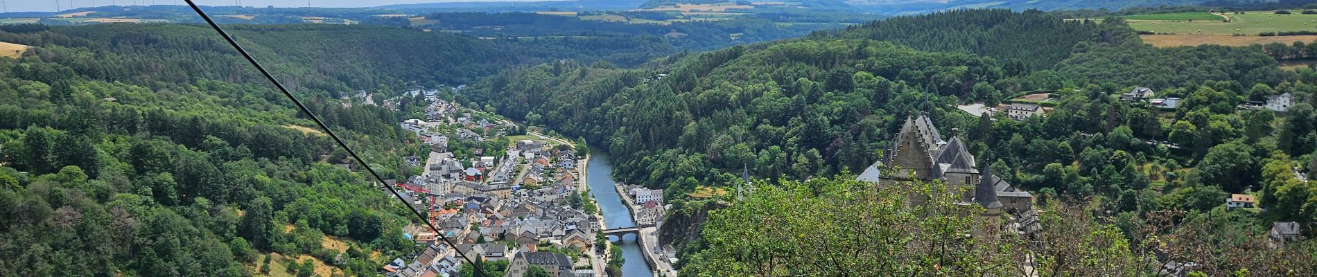
Un parcours boisé passant au sommet du télésiège (à 440 m) d'où il y a une vue époustouflante en panoramique sur la ville, le château et le barrage.
Possibilité d'une pause au restaurant.
Le retour emprunte un joli sentier au bord de la montagne.
A combiner avec la visite du château à l'arrivée.
www.vianden.lu
📌 & 🅿️ du château, max 5h00 pour 4 euros.

Elevation profile

Photos

Positioning

Country:
Luxembourg
Region :
Unknown
Department/Province :
Canton Vianden
Municipality :
Vianden
Location:
Unknown
Start:(UTM)
298892 ; 5535085 (32U) N.

Comments

Please log in to post a review or rate the element


Courte mais hard ! Faite avec Luna 🐕


Close
My subscriptions